
Last Updated
Overview
DatuBIM is transforming construction with solutions that improve efficiency, accuracy, and collaboration. It provides a centralized, always-updated data source for timely, cost-effective, and high-quality project execution. While large datasets can cause occasional lag, they offer powerful tools for site documentation and real-time task tracking.
DatuBIM Specifications
- Customizable Dashboards
- Data Visualization
- Data Analysis and Reporting
- Scheduled Reporting
What Is DatuBIM?
DatuBIM software is a robust SaaS platform for construction data analytics and management powered by AI and photogrammetric drone mapping. It transforms drone and laser scanning data into survey-grade 3D models and maps. By enabling design and as-built comparisons, delivering detailed analytics, and fostering collaboration, DatuBIM empowers stakeholders to make data-driven decisions and monitor project progress efficiently from anywhere.
DatuBIM Pricing
DatuBIM Integrations
Who Is DatuBIM For?
DatuBIM is designed to support:
- Business owners
- General contractors
- Engineering and consulting firms
- CAD designers
- Project managers
- Construction managers
- Quality assurance professionals
Is DatuBIM Right For You?
DatuBIM offers a transformative solution for managing large-scale civil construction projects, turning drone data into valuable insights and detailed reports. Designed for project managers, construction professionals, quality assurance experts, and CAD designers, it streamlines processes and enhances project execution, helping teams achieve superior results in complex projects.
Are you still unsure about DatuBIM? Call our team at (661) 384-7070 for expert guidance on your questions.
DatuBIM Features
Reporting And Documentation
Field data collection is simplified with automated report generation and digital project documentation. It ensures seamless sharing of updates, keeping stakeholders consistently informed and aligned throughout every phase of the project lifecycle.
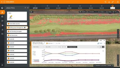
Ongoing Data And Analytics
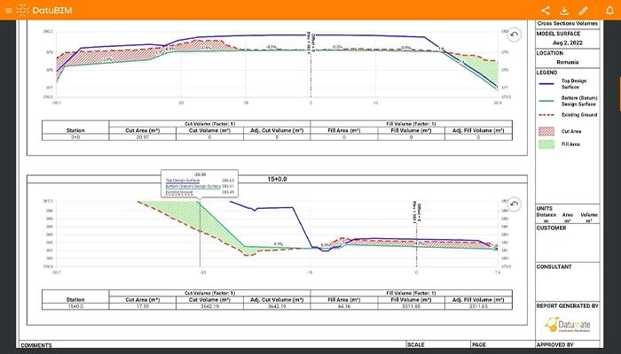
Accurate engineering data and process analytics enable proactive project management, allowing teams to stay hands-on and informed. Additionally, generating state and progress reports becomes effortless, simplifying the process with just a single click.
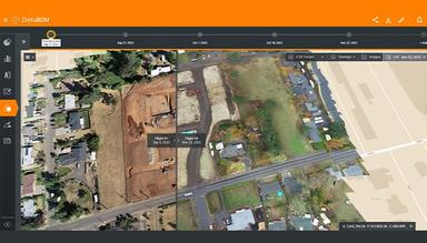
Visualization And Progress Monitoring
Execution progress can be tracked by comparing digital twins of a construction site across different dates. It enables clear comparisons between design, pre-construction, and as-built phases, helping ensure alignment with schedules and design plans.
Supervision And Quality Control
High-resolution drone imagery can optimize quality assurance, inspection, and supervision processes for enhanced site monitoring. This approach improves quality control measures and provides accurate, detailed oversight of a project's progress.
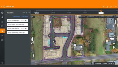
Annotations For Easy Collaboration
Georeferenced annotations on any image or file type simplify collaboration with stakeholders. Annotations can be assigned to specific users, ensuring updates and changes are communicated effectively to maintain project alignment.
Pros And Cons of DatuBIM
Pros
Powerful tools for site documentation
User-friendly interface
Effective for tracking project progress and comparing real-time data
Advanced drone imagery integration
Cons
Performance issues with large datasets
Manual design updates can be cumbersome
DatuBIM Reviews
Total 10 reviews
5
All reviews are from verified customers
Rating Distribution
5
Stars100%
4
Stars0%
3
Stars0%
2
Stars0%
1
Stars0%
Share your experience
Ohad
Human Resources, 500+ employees
More than a year
“DATUBIM is an excellent software for monitoring and controlling infrastructure works”
Pros
The ability to document, track and control projects remotely is invaluable, especially for development and railway projects. We regularly use it in collaboration with management companies, clients and all project stakeholders. It allows for planning presentations over current field photos, various data analyses, comparisons of planning vs execution and retrospective reviews at different points along the project timeline.
Cons
Some features related to the integration of computer image processing capabilities are lacking according to me.
Rating Distribution
Ease of use
10
Value for money
10
Customer Support
10
Functionality
10
Anonymous
Construction, 11-50 employees
“User friendly drone operator”
Pros
Great visuals and aesthetics, extremely helpful in our construction projects. The Asmade features are fantastic. The platform is userfriendly and easy.
Cons
It is difficult for me to upload images without GPS coordinates is difficult.
Rating Distribution
Ease of use
9
Value for money
10
Customer Support
10
Functionality
10
Anonymous
Engineering, 11-50 employees
Less than a year
“Amazing tool for designing landscapes in real”
Pros
Managing design uploads to identify conflicts is a key feature for me.
Cons
It doesn't include features for drawing or writing comments.
Rating Distribution
Ease of use
10
Value for money
10
Customer Support
10
Functionality
9
Frequently Asked Questions
Does DatuBIM offer an API?
No, DatuBIM does not offer API access.
What language does DatuBIM support?
DatuBIM supports English, Hebrew, Japanese, Chinese, German, and other languages with Latin-based letters and accents.
Does DatuBIM offer a mobile app?
DatuBIM doesn't have a dedicated mobile app, but it can be accessed on tablets via recommended internet browsers such as Chrome, Edge, or Brave.
What other apps does DatuBIM integrate with?
The vendor has not provided a list of integrations.
What types of pricing plans does DatuBIM offer?
The DatuBIM cost structure is based on the number of user licenses and images processed, with no restrictions on the number of projects or drones utilized by the organization. Users can request a detailed analysis of the DatuBIM price.
Who are the typical users of DatuBIM?
DatuBIM is designed to support business owners, general contractors, engineering and consulting firms, CAD designers, project managers, construction managers, quality assurance professionals, and teams handling multi-million-dollar projects.
What level of support does DatuBIM offer?
DatuBIM provides support through phone, email, help desk, FAQs/forums, and a knowledge base.