
Last Updated
Overview
Mapware offers a cloud-based mapping platform that simplifies 3D mapping and aerial photogrammetry. Although its strong internet connection requirement may be challenging for users in areas with unstable networks, its efficiency and scalability make it a top choice for large-scale mapping projects. Users laud its processing time and security reliability.
Be the first one to leave a review!
No review found
Starting Price
Custom
Mapware Specifications
- Scheduled Reporting
- Customizable dashboards
- Funnel analysis
- AI-Powered Insights
What Is Mapware?
Mapware is a cloud-based platform designed to assist industries such as construction and agriculture with efficient 3D mapping and aerial data processing. It streamlines workflows by enabling fast, scalable mapping solutions, reducing manual effort, and increasing data accuracy. The software serves a broad range of professionals, including drone operators and land surveyors. With secure cloud storage and an intuitive interface, Mapware addresses the need for precise, large-scale mapping while enhancing collaboration across teams.
Mapware Pricing
The Mapware price ranges in the five packages:
- Pay-As-You-Go: $0.02/megapixel
- Explorer: $140/month with annual plan
- Section: $837/month with annual plan
- Crew: $1673/month with annual plan
- Executive: $3346/month with annual plan
Disclaimer: The pricing is subject to change.
Mapware Integrations
Who Is Mapware For?
The software is for businesses of all sizes across various industries, such as:
- Oil and gas
- Utilities
- Construction
- Telecom
- Property management
- Defense
- Agriculture
Is Mapware Right For You?
Mapware is ideal for businesses needing accurate 3D maps and aerial data processing. Its cloud-based platform simplifies complex mapping workflows, improving project efficiency and decision-making. With scalable, high-quality solutions, the software helps organizations optimize their operations. That’s why the US Air Force, COMCAST, and Belfor use Mapware.
Still not sure about Mapware software? Contact our support team at (661) 384-7070 and get assistance regarding any further queries.
Mapware Features
Turf-Health Monitoring
Users can access aerial imagery to assess plant health and detect issues like drought or disease. It provides users in agriculture and landscaping with actionable insights, helping them optimize care, improve yields, and prevent costly damage.
Environmental Mapping
Mapware helps monitor and analyze landscapes in real time to offer insights into environmental changes. It provides accurate data for land management, conservation efforts, and environmental assessments, ensuring informed decision-making.
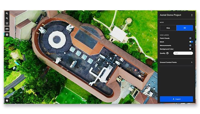
High-Quality Maps And Models
The software generates high-resolution maps and models for various industries, improving visualization and analysis. These quality outputs support better planning and design for users to assess project viability and environmental impact with increased clarity and accuracy.
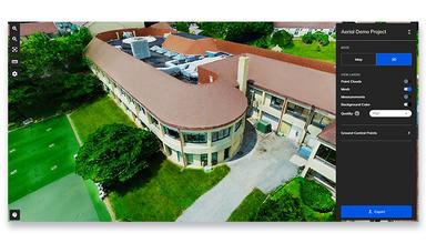
3D Model Creation
This feature converts aerial imagery into detailed, interactive 3D models. This capability enhances visualization and offers improved accuracy for construction, urban planning, and environmental studies, enabling better design and decision-making.
GPU-Accelerated Processing
With GPU-accelerated processing, Mapware speeds up data analysis and model rendering, allowing for quicker project turnaround times. The software efficiently handles large datasets, improves workflow speed, and reduces data processing delays.
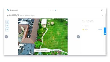
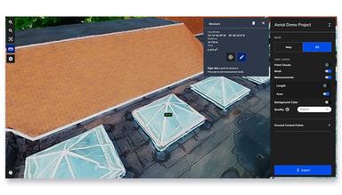
Data Surveying
It facilitates precise data collection through aerial surveys, enabling users to gather geospatial information efficiently. By automating survey processes, it reduces time and effort for faster and more accurate analysis.
Pros And Cons of Mapware
Pros
Simple interface and easy navigation
Supports improved results with its data accuracy
Enables fast uploading of photos
Streamlined account sharing and cloud processing
Great quality of models and exports
Cons
Can be very expensive for smaller businesses
Pruning source images can be time-consuming, according to some software users
Occasional glitches during updates
Mapware Reviews
No reviews yet!
Be the first to review this product
Frequently Asked Questions
Does Mapware offer an API?
Yes, Mapware provides an API.
What language does Mapware support?
Mapware supports the English language.
What other apps does Mapware integrate with?
The official website doesn’t disclose its details, but you can schedule a free Mapware demo to learn about its integrations.
Does Mapware have a mobile app?
Yes, Mapware has a mobile app.
What type of pricing plans does Mapware offer?
Mapware price starts at $0.02/megapixel for the Pay-As-You-Go plan, $140/month for the Explorer plan, $837/month for the Section plan, $1673/month for the Crew plan, and $3346/month for the Executive plan. Users can also request an estimate for a tailored plan.
Who are the typical users of Mapware?
Mapware is typically used by those in construction, telecom, oil and gas, defense, agriculture, utilities, and other related industries.
What level of support does Mapware offer?
Mapware offers support through email, phone, FAQs, and a knowledge base.