
Last Updated
Overview
SAGA GIS is a comprehensive geospatial analysis platform that delivers advanced terrain modeling, spatial data processing, and environmental mapping capabilities to support infrastructure and facility planning decisions. While the platform may require some improvement in its big data handling capability, it enables powerful raster and vector analysis.
Be the first one to leave a review!
No review found
Starting Price
Custom
SAGA GIS Specifications
- Reporting And Analytics Dashboards
- Compliance And Safety Management
- Energy Performance Analysis
- Space Management And Planning
What Is SAGA GIS?
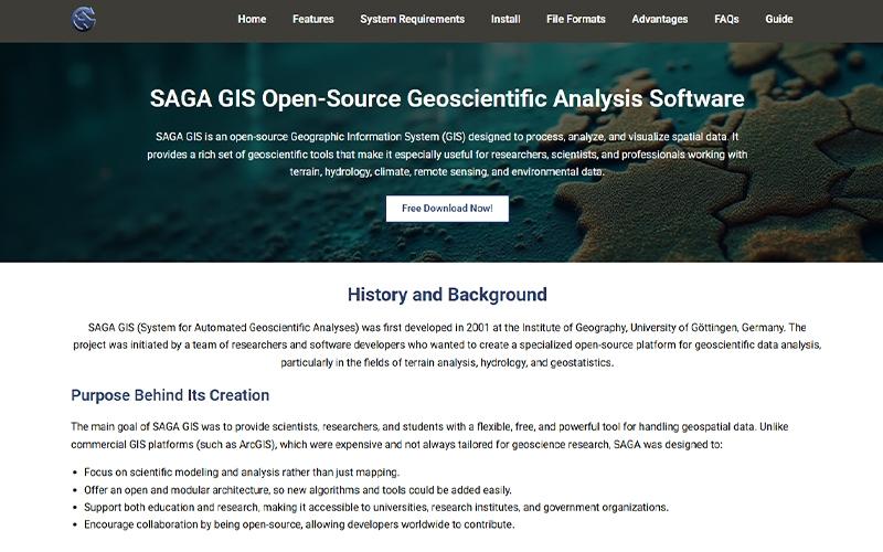
SAGA GIS is an extensive geospatial analysis platform that offers comprehensive spatial data processing capabilities to support infrastructure planning, environmental monitoring, and facility site analysis. It provides tools for analyzing raster and vector datasets such as satellite imagery, elevation models, and climate data. The platform enables terrain analysis, watershed modeling, and geostatistical calculations that assist organizations in evaluating land conditions and geographic constraints. It also supports visualization of spatial datasets through layered maps, analytical charts, and three-dimensional terrain models.
How Much Does SAGA GIS Cost?
SAGA GIS pricing is an open-source platform that requires no payment from the users. This pricing is intended for general budgeting purposes, as actual costs can vary based on number of users, selected feature tiers, and required integrations.
In addition to the base subscription costs, organizations should account for the following estimated expenses that are sourced from third-party websites:
- Implementation and onboarding costs: $10,000-$50,000 at Basic level; $50,000-$150,000 at medium complexity; $150,000 at high-end
Disclaimer: The pricing is subject to change.
SAGA GIS Integrations
Who Is SAGA GIS For?
SAGA GIS is suitable for the following sectors:
- Education
- Environmental research
- Government
Is SAGA GIS Right For You?
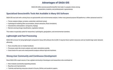
SAGA GIS is suitable for businesses aiming to evaluate geographic environments and spatial datasets supporting facility planning and environmental assessment. It enables terrain modeling, hydrological analysis, and spatial data processing across complex geographic datasets. The platform also supports raster analysis, geostatistical modeling, and terrain visualization to help organizations interpret environmental conditions for planning and operational decisions.
Still not sure if SAGA GIS is right for you? Contact our customer helpline at (661) 384‑7070 for further guidance.
SAGA GIS Features
Geoscientific Modules
SAGA GIS provides a comprehensive collection of geoscientific modules that support terrain analysis, hydrological modeling, and environmental data processing. These modules enable organizations to perform spatial analysis for land assessment and environmental monitoring.
Cross-Platform Compatibilty
The system supports multiple operating systems including ‘Windows’, ‘Linux’, and ‘macOS’. This cross-platform compatibility enables organizations to deploy the software across different systems while maintaining consistent geospatial analysis and data management capabilities.
Raster And Vector Data Management
The software allows users to manage and analyze both raster and vector spatial datasets efficiently. It offers tools for spatial visualization, geoprocessing, and geographic data analysis to support planning, mapping, and environmental studies.
Pros And Cons of SAGA GIS
Pros
Supports raster and vector spatial dataset processing
Provides extensive geospatial analysis modules
Facilitates spatial visualization through maps and ‘3D’ terrain models
Cons
The platform may offer limited compatibility with various formats
It may offer limited advanced tools for digital image processing
SAGA GIS Reviews
No reviews yet!
Be the first to review this product
Frequently Asked Questions
What language does SAGA GIS support?
SAGA GIS supports English language only.
Does SAGA GIS offer an API?
Yes, SAGA GIS software does offer an API.
What types of pricing plans does SAGA GIS offer?
It is an open-source platform that requires no payment from the users. Get a customized SAGA GIS cost breakdown for your business today.
Does SAGA GIS have a mobile app?
No, SAGA GIS software does not offer a mobile app.
Who are the typical users of SAGA GIS?
The typical users of SAGA GIS include sectors like education, environmental research, and government.
What other apps does SAGA GIS integrate with?
SAGA GIS software integrates with QGIS.
What level of support does SAGA GIS offer?
SAGA GIS offers support through email and form submission.