
Last Updated
Overview
Ride With GPS offers detailed mapping and navigation solutions for managing cycling fleets. While real-time rider tracking requires specialized hardware, its ability to create custom cues and points of interest significantly enhances the rider experience. However, its specialized toolset makes it an essential platform for bike-based operations and tourism.
Be the first one to leave a review!
No review found
Starting Price
Custom

Ride With GPS Specifications
- Route Optimization
- Trip History Logging
- Telematics Integration
- Vehicle Tracking (GPS)
What Is Ride With GPS?
Ride With GPS is a comprehensive Route Planning and Navigation platform designed to support cycling organizations, clubs, and tour operators. The software enables businesses to create detailed courses with turn-by-turn voice navigation, ensuring clients and members stay on track. Moreover, it addresses the challenge of distributing complex navigation data by offering advanced offline map capabilities and a centralized route library. In this regard, Ride With GPS scales effectively for organizations seeking to streamline logistics and enhance rider safety.
Ride With GPS Pricing
The Ride With GPS cost begins with a free Starter plan. Moreover, the software also includes the following two paid plans with a 7-day free trial:
- Basic: $7.99/month
- Premium: $9.99/month
Disclaimer: The pricing is subject to change.
Ride With GPS Integrations
The software supports integration with multiple platforms, such as:
- Strava
- RunGap
- Epic Ride Weather
- ROUVY
- Squadrats
Who Is Ride With GPS For?
Ride With GPS is ideal for cycling clubs, tour operators, event organizers, bike rental shops, and individual cyclists who want to plan, navigate, track, and share GPS-based bike routes.
Is Ride With GPS Right For You?
If your business relies on precise route planning and reliable navigation for cycling groups, Ride With GPS is an excellent contender. Its standout turn-by-turn voice navigation and offline map access distinguish it from competitors, ensuring rider safety and satisfaction. Ideal for tour operators and event managers, this platform simplifies route sharing. With robust tools for managing comprehensive route libraries, Ride With GPS efficiently supports scaling operations and enhances client experience.
Still not sure about Ride With GPS? Contact our support team at (661) 384-7070 for further guidance.
Ride With GPS Features
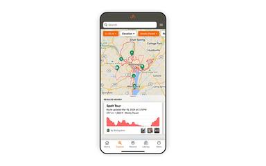
Route Planning
This feature enables users to create detailed routes using an intuitive interface with smart anchor points. It supports efficient drag-and-drop of route lines, allowing planners to adjust paths quickly while maintaining precise navigation data for riders and fleet managers.
Collaborative Collections
Ride With GPS supports collaborative libraries where multiple users can contribute and manage routes within a single collection. This functionality streamlines event organization by allowing teams to curate, update, and share route lists seamlessly with participants or club members.
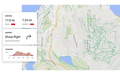
Advanced Map Layers
The platform provides access to specialized map types, including heatmaps and terrain views, directly on mobile devices. It allows users to visualize road surfaces and traffic data, ensuring safer and more informed route selection for diverse cycling groups.
Clickable Thumbnails
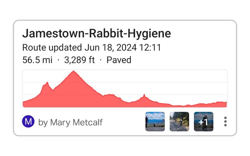
The software enables users to interact with photo thumbnails on the map to preview specific locations before riding. It enhances route discovery by providing visual context. In this regard, Ride With GPS helps organizers and riders assess the suitability of the terrain and scenery before departure.
Waypoints
Ride With GPS allows users to add custom points of interest with detailed notes and photos along any route. This capability ensures that riders receive critical information about rest stops, hazards, or scenic locations exactly when they need it during navigation.
Pros And Cons of Ride With GPS
Pros
Comes with reliable offline map capabilities
Supports seamless device synchronization options
Comprehensive route planning tools are available
Cons
Navigation instructions are sometimes inaccurate in complex areas
Exported GPX files may omit extra data, such as POIs
Ride With GPS Reviews
No reviews yet!
Be the first to review this product
Frequently Asked Questions
What language does Ride With GPS support?
Ride With GPS is primarily available in English, French, Dutch, German, Spanish, Italian, and Japanese.
Does Ride With GPS offer an API?
Yes, Ride With GPS offers an API.
What types of pricing plans does Ride With GPS offer?
The Ride With GPS price begins with a free Starter plan, alongside paid options starting at $7.99/month for the Basic plan and $9.99/month for the Premium plan. Request a personalized Ride With GPS pricing quote for your business.
Who are the typical users of Ride With GPS?
The typical users of Ride With GPS features are cycling clubs, tour operators, event organizers, bike rental shops, and individual cyclists who want to plan, navigate, track, and share GPS-based bike routes.
Does Ride With GPS have a mobile app?
Yes, Ride With GPS offers a mobile app for both Android and iOS devices.
What other apps does Ride With GPS integrate with?
Ride With GPS software integrates with various third-party platforms, such as Strava, RunGap, Epic Ride Weather, ROUVY, and Squadrats.
What level of support does Ride With GPS offer?
Ride With GPS provides support through email, ticket submission, and a help center.