
Last Updated
Overview
PropertyIntel helps landscaping and irrigation teams produce accurate digital takeoffs with map-based measuring, collaboration, and an AI-powered ProMaps feature recognition with slope views. While it doesn’t have a dedicated mobile app, its mobile-optimized web app supports work on the go. Overall, it fits estimators and contractors needing faster bids.
Be the first one to leave a review!
No review found
Starting Price
Custom
PropertyIntel Specifications
- Reporting And Analytics Dashboards
- Mobile Accessibility
- CAD/BIM Integration
- Vendor Contract Management
What Is PropertyIntel?
PropertyIntel is a measurement and estimating software solution designed for landscape contractors and businesses placing bids for maintenance, design-build, and enhancement projects. It enables users to collect, connect, and visualize essential property data using aerial imagery, precision measuring tools, automated estimating, visual proposals, and Aspire platform integration. The software supports takeoffs, job plans, reports, and dashboards. It helps users complete accurate estimates, respond to bid requests efficiently, and identify revenue opportunities through connected data insights.
PropertyIntel Pricing
PropertyIntel price starts at $199/month for its Essential plan, which includes basic tools and one user. Further pricing tiers of the software are as follows:
- Advanced: $499/month
- Enterprise: Custom pricing
According to our estimate, the implementation costs might vary between $0 to $5,000 for PropertyIntel software, depending on team size, training needs, and any Aspire platform rollout.
Disclaimer: Pricing references are based on publicly available third-party information and industry benchmarks. Actual costs may vary.
PropertyIntel Integrations
The software supports integration with multiple systems and platforms, such as:
- MindCloud
- SiteOne
- Spentra
- Protiv
- Proposify
- Scorpion software
Who Is PropertyIntel For?
PropertyIntel is ideal for a wide range of industries and service providers, including:
- Landscaping services
- Grounds maintenance
- Landscape construction
- Irrigation services
- Snow and ice management
- Property services and site audits
- Facilities services
Is PropertyIntel Right For You?
If you’re a landscape contractor looking to collect, connect, and visualize essential property data to bid, win, and service more jobs in less time, PropertyIntel is designed to support those goals. It is built for businesses placing bids for maintenance, design-build, and enhancement projects, with plans suited for small, midsize, and large companies.
PropertyIntel is certified for the latest ISO 27001:2022 standard and is trusted by LandCare, Yellowstone Landscape, Landscape Workshop, and Pacific Grounds Management. If your focus is on improving data accuracy and operational clarity, it may be a suitable fit.
Still doubtful if PropertyIntel software is the right fit for you? Connect with our customer support staff at (661) 384-7070 for further guidance.
PropertyIntel Features
Automated Estimating
The platform calculates time, material, and cost estimates automatically as measurements are collected. It integrates with your own pricing database or the Aspire platform to minimize manual entry errors. By automating these calculations, users can save time, improve accuracy, and generate reliable project budgets for each property.
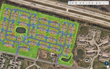
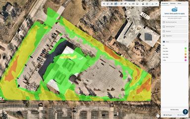
Reference Maps
PropertyIntel allows users to generate shareable reference maps for easy communication with clients and internal teams. The software lets users place pins to highlight areas of interest, link to specific projects, and visually track enhancement ideas or issues. This improves collaboration and ensures that all stakeholders have a clear view of the property.
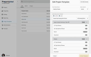
Precision Measuring Tools
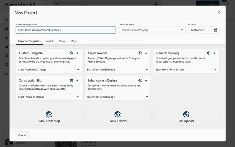
PropertyIntel provides precision measuring tools that allow landscape contractors to gather accurate property measurements efficiently. The software supports takeoffs for maintenance work, design-build projects, and enhancement opportunities. Users can streamline planning by ensuring data accuracy, reducing manual calculations, and simplifying complex measurement tasks across multiple properties.
Proposal Builder
PropertyIntel enables users to create and send visual proposals that include pricing breakdowns, color-coded project sitemaps, and customizable cover letters. The software helps contractors communicate project plans effectively to clients and internal teams, enhancing clarity, reducing misunderstandings, and supporting smoother proposal approval processes.
ProMaps
The software harnesses artificial intelligence to assist with property measurements and slope visualization. ProMaps allows contractors to analyze complex terrain features accurately, supporting better project planning and design decisions. Users benefit from improved precision in mapping, which enhances overall efficiency and reduces the risk of errors during implementation.
Pros And Cons of PropertyIntel
Pros
Faster, more accurate takeoff results
Cloud collaboration supports multiple team members
High-quality maps and editing tools
Cons
Export layering may need adjustments
Self-measuring may feel time-consuming
PropertyIntel Reviews
No reviews yet!
Be the first to review this product
Frequently Asked Questions
Does PropertyIntel have a mobile app?
No, PropertyIntel does not offer a dedicated mobile app.
Does PropertyIntel offer an API?
Yes, PropertyIntel offers an API.
What types of pricing plans does PropertyIntel offer?
The vendor offers customized pricing tailored to your business requirements. Get a detailed PropertyIntel cost breakdown tailored to your specific requirements.
What language does PropertyIntel support?
PropertyIntel primarily supports the English language.
What other apps does PropertyIntel integrate with?
PropertyIntel integrates with multiple systems and platforms, including Proposify, MindCloud, SiteOne, Spentra, and Protiv.
What level of support does PropertyIntel offer?
PropertyIntel offers support through phone.
Who are the typical users of PropertyIntel?
PropertyIntel features are used by a wide range of industries and service providers, including landscape construction, landscaping services, and grounds maintenance.