
Last Updated
Overview
OpenSpace software delivers advanced reality capture and construction management tools, enabling precise project tracking and collaboration through AI-powered technology. Designed for efficiency, it enhances visibility and accountability across teams. Limited offline functionality can affect remote site use, but exceptional documentation capabilities significantly streamline workflows and decision-making processes.
OpenSpace Specifications
- Mobile App
- Document Management
- Progress Tracking
- Reporting and Analytics
What Is OpenSpace?
OpenSpace features a fast and intuitive way to visually document jobsites, generating Google Street-style views with minimal effort. By attaching a 360° camera to a hard hat or drone, the platform automates reality capture, AI-driven image mapping, and Field Notes. Designed for mid- to large-scale construction projects, it enhances QA/QC workflows, strengthens coordination, accelerates visual record-keeping, and facilitates proactive issue resolution through clear progress insights.
OpenSpace Pricing
OpenSpace Integrations
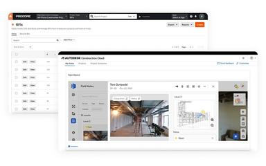
The platform seamlessly integrates with various applications, including:
- Procore
- Autodesk Construction Cloud
- PlanGrid
- Revizto
Who Is OpenSpace For?
The platform supports professionals in the construction industry including:
- General contractors
- Owners
- Trade firms
Is OpenSpace Right For You?
OpenSpace serves construction teams that require rapid, visual documentation and streamlined progress tracking. The platform’s standout Spatial AI engine, integration capabilities, and scalability make it a compelling choice for general contractors, trade firms, and owners aiming to reduce rework, risk, and inefficiencies. SOC 2 and FedRAMP-Moderate certified, it supports enterprise-grade security.
Still doubtful if OpenSpace software is the right fit for you? Connect with our customer support staff at (661) 384-7070 for further guidance.
OpenSpace Features
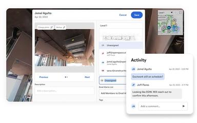
Field Notes
The software attaches images and notes to exact floor plan locations, automatically pinning observations during 360° walkthroughs. Field Notes enable contextual issue capture, create traceable records, and simplify communication between field and office stakeholders efficiently.
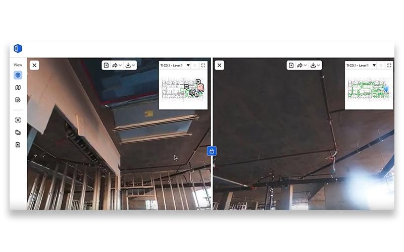
BIM Viewer
OpenSpace’s BIM Viewer presents uploaded BIM models side by side with captures. It enables comparison to identify discrepancies, validate construction progress against design intent, and align on site conditions with project documentation to support coordination efforts.
Captures
OpenSpace organizes all project captures, showing the most recent first. Each capture displays level and date, supports custom naming for clarity, and includes a search bar to quickly retrieve specific captures from the archive efficiently.
Shared Folders
The platform enables creation and naming of shared folders to group captures, assign access, and invite collaborators. This streamlines navigation, centralizes project media, and reduces time spent locating relevant imagery across teams and workflows seamlessly.
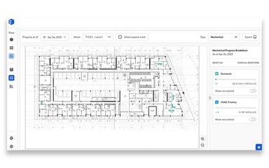
Insights
Insights provides access to OpenSpace Track analytics within Images and Sheets views, presenting Overview, Details, and Progress Chart tabs. These dashboards summarize milestone status, highlight trends, and expose progress variances for informed schedule adjustments promptly.
Pros And Cons of OpenSpace
Pros
Captures 360° imagery to document overlooked details
Advanced modeling capabilities for realistic spatial representation
Improves understanding of site clearances and tolerances
Cons
Desktop sync software needs improvement
No option to adjust capture frequency
OpenSpace Reviews
Total 7 reviews
4
All reviews are from verified customers
Rating Distribution
5
Stars43%
4
Stars29%
3
Stars14%
2
Stars14%
1
Stars0%
Share your experience
John C.
Small-Business, 11-50 employees
“Great dealership management solution”
Pros
I can map a site in under 30 minutes depending on the size, which saves me tons of time.
Cons
I haven't encountered any problems so far, though we've only tested it a handful of times.
Rating Distribution
Ease of use
5
Value for money
7
Customer Support
7
Functionality
6
Anonymous
Enterprise, 500+ employees
“Excellent Tool for Construction Tracking”
Pros
It is really helpful for tracking every phase from earthwork all the way to completion. I can pull it up when coordinating between trades or giving updates to my managers. Makes it easy to view the project remotely without having to be on site.
Cons
Tracking different areas separately is a real pain point for me. When I try to view outdoor spaces or anything outside the main drawing, it just doesn't function properly. The sitework gets mixed up with first floor data which makes no sense for my workflow. I really need each floor and designated area to have its own separate tracking system - right now everything gets jumbled together and it's frustrating to sort through.
Rating Distribution
Ease of use
7
Value for money
8
Customer Support
8
Functionality
6
Sarah B.
Enterprise, 500+ employees
“Perfect for Remote Work”
Pros
I really appreciate how it handles live data visualization from observations, simulations and mission planning operations. The interactive presentation features make working with dynamic datasets much more engaging and effective.
Cons
I honestly can't think of any major downsides, this is a solid product overall!
Rating Distribution
Ease of use
9
Value for money
9
Customer Support
9
Functionality
9
Frequently Asked Questions
Does OpenSpace offer an API?
Yes, OpenSpace offers an API.
Does OpenSpace have a mobile app?
Yes, OpenSpace offers a dedicated mobile application for iOS and Android devices.
What language does OpenSpace support?
OpenSpace supports English, Japanese, German, and Dutch.
What types of pricing plans does OpenSpace offer?
The OpenSpace price layout is based on chosen products and annual construction volume, offered through annual subscriptions tailored to business needs. Request a detailed OpenSpace cost breakdown for your organization today.
What other apps does OpenSpace integrate with?
OpenSpace integrates with Revizto, Procore, Autodesk Construction Cloud, and PlanGrid.
Who are the typical users of OpenSpace software?
Typical users include general contractors, owners, and professionals in the trades sector.
What level of support does OpenSpace offer?
OpenSpace provides dedicated onboarding and customer success managers, access to OpenSpace Academy, and support via email, chat, a help center, support form, and FAQs.