
Last Updated
Overview
EagleView delivers high-resolution aerial imagery and 3D property data, supporting roofing, insurance, and solar assessments. While some users report occasional issues with customer service, its AI-driven measurements, accurate analytics, and seamless integration make it a reliable tool for informed decision-making and efficient project planning.
EagleView Specifications
- Document Management
- Collaboration and Communication
- Reporting and Analytics
- Budget Management
What Is EagleView?
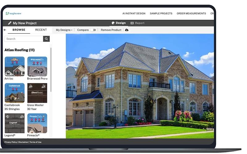
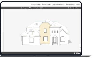
EagleView is a property intelligence solution that transforms high-resolution aerial imagery into actionable data for businesses. It provides detailed 3D property visualizations and AI-driven insights, allowing professionals in roofing, construction, solar, and insurance to perform precise assessments from their desks. This technology helps organizations reduce costly site visits, increase field personnel safety, and streamline the estimation process, ultimately improving operational efficiency and boosting overall profitability.
EagleView Pricing
EagleView pricing for its premium plan is structured as follows:
Residential:
- Small (20 sq): Starting at $32.75
- Medium (40 sq): Starting at $60
- Large (40+ sq): Starting at $87
Commercial: Starting at $89.50
Full house (Residential): Starting at $105
Disclaimer: The pricing is subject to change.
EagleView Integrations
The software supports integration with multiple systems and platforms, such as:
- AccuLynx Software
- Contractors Cloud
- Estimating Edge
- JobNimbus Software
- JobTread
- Leap
- Roofle
Who Is EagleView For?
EagleView is ideal for a wide range of industries and sectors, including:
- Roofing
- Solar
- Insurance
- Government
- Utilities and energy
- Telecom
- Real estate
Is EagleView Right For You?
EagleView is the definitive choice for businesses looking to replace manual site inspections with validated, best-in-class aerial data. Its value is highlighted by numerous accolades, including the MAPPS Geospatial Excellence Award, demonstrating its unique technology that delivers superior accuracy and operational efficiency.
Still doubtful if EagleView is the right fit for you? Connect with our customer support staff at (661) 384-7070 for further guidance.
EagleView Features
Asset Management
EagleView enables organizations to identify and monitor small infrastructure elements such as signage, fire hydrants, and light poles. The software supports tracking, verification, inspection, and reporting of assets, helping municipalities, utilities, and construction teams maintain accurate records and streamline management.
Urban Planning
The platform delivers highly detailed spatial data for mapping, project planning, and urban development initiatives. Users can extract precise measurements, land classifications, and planning insights, enabling smarter infrastructure design, zoning decisions, and strategic urban growth management with enhanced efficiency.
Property Intelligence
The software leverages AI-powered models to analyze roof conditions, classify land use, and monitor infrastructure. Users gain predictive insights, identify potential risks, and enhance maintenance planning, enabling data-driven decisions that improve property evaluations, operational efficiency, and long-term asset performance.
Property Assessment
EagleView allows users to analyze granular construction details, building materials, and grading to precisely evaluate the value of a property. The software provides actionable insights for appraisals, insurance assessments, and real estate decision-making, improving accuracy and reducing manual site visits.
Pros And Cons of EagleView
Pros
Detailed reports speed up estimating and material orders
Highly accurate aerial roof and property measurements
Suggested waste factor improves material estimation
Cons
Tree obstructions can affect measurement accuracy
Limited coverage for remote locations
EagleView Reviews
Total 10 reviews
4.1
All reviews are from verified customers
Rating Distribution
5
Stars40%
4
Stars30%
3
Stars30%
2
Stars0%
1
Stars0%
Share your experience
Michael D.
Small-Business, 11-50 employees
“Detailed and accurate measurements”
Pros
I can easily access a huge archive of historical images that give me super detailed measurements for my projects.
Cons
I haven't run into any downsides for measuring residential roofs so far.
Rating Distribution
Ease of use
10
Value for money
10
Customer Support
10
Functionality
10
Lily W.
Small-Business, 11-50 employees
“Measurement Problems Persist”
Pros
Their customization options really need some work and there's not much flexibility in how you can set up the interface. It's also pretty pricey compared to other options and the measurements aren't as accurate as I'd like. The photo quality could definitely be better for the price you're paying.
Cons
The editing is pretty limited. I can't rotate or adjust images to custom angles. I'm stuck with whatever preset views are available. Having more freedom here would really help me be more accurate with my analysis.
Rating Distribution
Ease of use
6
Value for money
5
Customer Support
6
Functionality
5
John T.
Small-Business, 11-50 employees
“Poor Accuracy and Slow Image Processing”
Pros
The customization features definitely need some improvement. It's frustrating considering what you're paying for. Also, the pricing changes depending on the size of your reports which isn't great. Overall, my experience with this platform hasn't been the best.
Cons
The photo adjustment options could definitely be more easy. I can rotate and tilt images to get the angles I need for assessments but the whole process feels difficult and requires a lot of manual work with uploading and processing.
Rating Distribution
Ease of use
5
Value for money
4
Customer Support
5
Functionality
5
Frequently Asked Questions
Does EagleView have a mobile app?
Yes, EagleView offers a dedicated mobile app for both iOS and Android.
Does EagleView offer an API?
Yes, EagleView offers an API.
What language does EagleView support?
EagleView software primarily supports English.
What level of support does EagleView offer?
EagleView offers comprehensive support, including live chat and email assistance, technical help for software and integrations, account management, FAQs, and detailed product guides.
What types of pricing plans does EagleView offer?
EagleView pricing for its premium plan is structured based on property type and size. For residential properties (bronze package), small homes (20 sq) start at $32.75, medium homes (40 sq) at $60, and large homes (40+ sq) at $87. Commercial properties start at $89.50. For a Full Home, pricing starts at $105. Get a detailed EagleView cost breakdown tailored to your specific requirements.
What other apps does EagleView integrate with?
EagleView supports integration with several platforms, including JobTread, Leap, Contractors Cloud, Estimating Edge, JobNimbus, Roofle, and AccuLynx.
Who are the typical users of EagleView?
EagleView features are used by roofing contractors, solar installers, insurance assessors, government agencies, utility and telecom managers, real estate professionals, and architecture, engineering and construction teams.