
Last Updated
Overview
InSite Elevation Pro Specifications
- Accounting
- Bid Management
- Project Management
- Workflow Management
What Is InSite Elevation Pro Software?
Overview
Elevation Pro empowers earthwork and utility professionals to minimize risk, save time, and achieve seamless field coordination through accurate takeoffs and GPS machine-control models. The platform equips users to tackle terrain challenges, calculate cut-and-fill volumes, and determine stripping and strata quantities. Additionally, the platform allows users to measure paving and concrete materials, plan topsoil redistribution, compute areas and lengths, and model trench excavation and backfill with precision.
Elevation Pro features a user-friendly CAD viewer that allows hassle-free import and export of CAD files. The vendor also offers complimentary training and expert 7-day support to ensure success. Elevation Pro is regularly updated to meet industry standards. Users don't have to worry about inaccurate bids being caused by outdated tools.
“InSite is a powerful tool with an easy-to-use interface"- Evan- Estimator
Elevation Pro Pricing
Elevation Pro Demo
InSite Construction Software Reviews
InSite Elevation Pro reviews are the best way to learn about the software from an existing user's perspective. According to users, this software is worth its price due to its robust features and unique capabilities. The software has an average of ⅘ star rating on most websites, indicating that users recommend it!
Our Thoughts
InSite Software solutions have assisted earthwork estimators in becoming more accurate, productive, and profitable for over 30 years. They are known for their software innovations and constantly expand their product offerings to meet their customers' growing productivity needs. Today, many estimators and engineers prefer InSite's Earthwork Take-Off & GPS Modeling Solutions. Contact us at (661) 384-7070 and get expert assistance from our team regarding any further queries.
InSite Elevation Pro Features
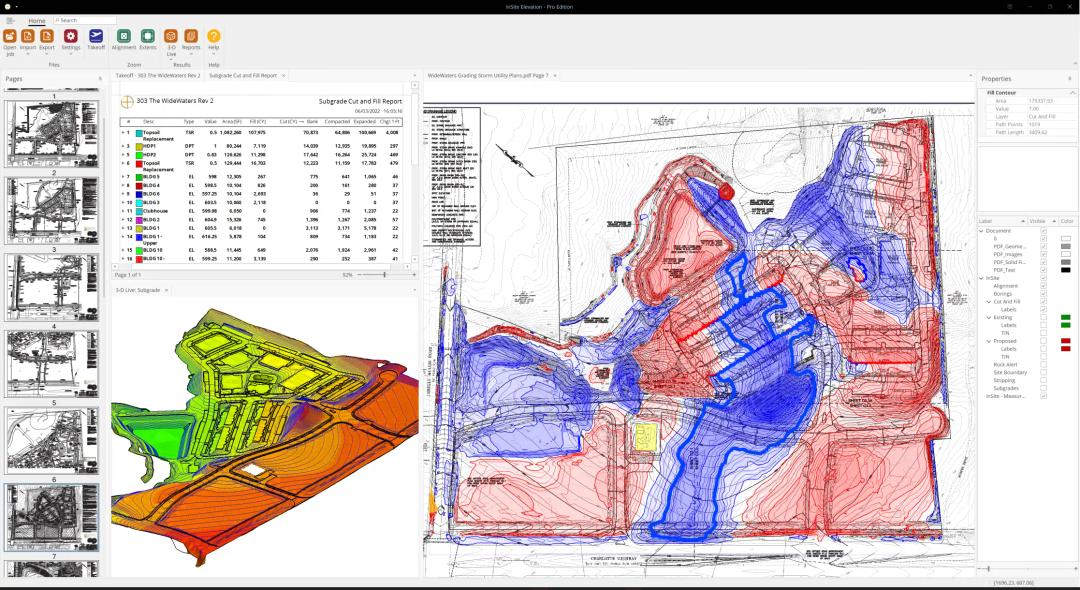
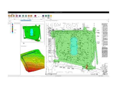
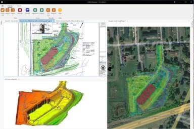
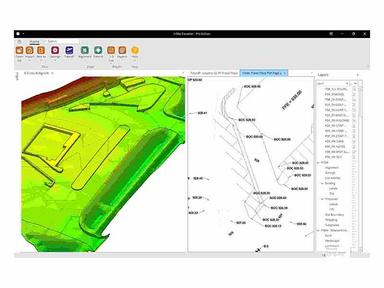
3D Graphics
InSite Elevation Pro provides detailed hard 3D graphic evidence of all site work calculations, which increases confidence for more accurate and tighter bidding.
Detailed Reports
InSite Elevation Pro offers a complete set of easy to understand earthwork reports that can be exported to spreadsheets, PDF files and most bid applications. Reports can be exported to PDF, HTML (web), XLS (Excel), RTF (Word, etc.) and other file formats and can be personalized with a watermark to add a professional appearance. Printing or exporting the report to PDF will include the watermark.
Area, Length & Item Count
InSite Elevation Pro makes it easy to take-off curb lengths, water and sewer lengths, surface of paving and count traffic control signs. Export the results to spreadsheet and PDF.
Utility Takeoff
TrenchVision 3D™ quickly and accurately provides excavation and backfill quantities for sanitary and storm sewers, water, electrical and gas service, using the earthwork contours from your site takeoffs.
Create GPS Machine Control
Once the bid is won, Elevation Pro gives you the tools to create GPS machine control models for CAT, Komatsu, Trimble, Topcon, Leica, etc., without needing a complex CAD program.
Value Engineering
New site designs can be contoured to validate changes with Elevation Pro’s Dynamic Site Balancer. Easily adjust site grades to achieve an acceptable balance, or adjust either an entire site or individual areas. Communicate changes with managers, engineering and developers to keep your earthwork projects on running time.
Built-in CAD Viewer
The built-in CAD viewer in InSite Elevation allows the import of existing and proposed grades and other site features on even the most significant projects. It also supports the latest generation of CAD files. As a result, there’s no need to invest in a costly CAD program as long as you’re using InSite software.
Open and Align Multiple Files
Elevation Pro opens and aligns multiple files of different types and scales such as vector files (PDF, DWG, DXF, etc.), image files (PDF, TIF, etc.), or data imported from a data collector. Takeoff data from any sources overlays all other sources, preventing missed items and double calculations.
Accurate Slope Area Calculation
Using Elevation Pro, users can access the plane area (top-down view) and the slope area (3D surface) calculations. Elevation Pro’s ability to provide precise slope area calculations allows estimators to confidently plan and allocate resources, minimizing wastage and maximizing efficiency. Elevation Pro’s versatility extends beyond pond liners and erosion control fabric. It’s also invaluable for calculating the face of retaining walls, preventing flawed estimations and compromised structural integrity.
Improve Communication on the Job Site
KMZ files provide location-based data to Google Earth and other geo-browsers to anyone on your staff with a GPS-equipped smart device with no special app required. Clearly see cut & fill, delivery, stockpile locations, haul routes, building locations, and utilities.
InSite Elevation Pro Reviews
Total 11 reviews
4.5
All reviews are from verified customers
Rating Distribution
5
Stars55%
4
Stars45%
3
Stars0%
2
Stars0%
1
Stars0%
Share your experience
John P.
Construction, 11-50 employees
“Accurate and dependable, but PDF features could be improved”
Pros
Insite has always been a reliable solution for me, thanks to its precision and exact amounts. What makes it more appealing is that it can be used for the smallest and the most significant projects alike. The InSite team is always searching for ways to improve the product. It also has a stable cloud connection, which ditches the USB key requirement and enables working remotely.
Cons
Its annoying that PDF is supposed to be in a vector format for the PDF takeoff feature to work flawlessly. When it isnt, which is always the case, performing the takeoff is difficult and time-consuming.
Rating Distribution
Ease of use
7
Value for money
7
Customer Support
7
Functionality
7
Rick
Construction, 1-10 employees
“Life saver!”
Pros
InSite has been saving my life for quite a while. I use Insite to calculate the quantities of our earthwork, pipe excavation and backfill, finish grade, asphalt, concrete, and topsoil. And make sure the amounts are precise. For our field survey and GPS layout, I utilize Field General. I create my own TINS to manage our GPS system.
Cons
While working with this software for so many years, I have noticed that the reports may be a little bit more in-depth in some cases. But overall, everything seems fine.
Rating Distribution
Ease of use
9
Value for money
9
Customer Support
9
Functionality
8
Bryan R.
Construction, 11-50 employees
“Insite is very helpful”
Pros
Most of my time is spent in the field so finding something that works this well was a joy to me. It is very accurate and my customer likes the 3D model.
Cons
You cannot basically scroll through a list of diagrams. You have to click on every one of them until you get to your desired one.
Rating Distribution
Ease of use
9
Value for money
8
Customer Support
8
Functionality
10
Frequently Asked Questions
What type of pricing plan does Insite Elevation pro offer?
Elevation Pro is sold as subscription. Contact the company for pricing details.
Who are the typical user of Insite Elevation pro?
Anyone that require accurate earthwork numbers, including grading contractors, GCs, and preconstruction and design-build firms.
What level of training and support does Insite offer?
Technical support is offered 7 days a week to ensure your team meets tight bidding deadlines. Onboarding and training classes are included in the subscription cost.
Do I need estimating experience to run the software?
InSite Elevation Pro is a tool for experienced estimators who have either done takeoff by hand using grid or average end methods or used other computerized systems. It is designed to be easier, faster, and more accurate, but knowledge of estimating grading and excavation and previous takeoff experience is required.
What files types Insite Elevation pro support?
InSite Elevation Pro combines data from multiple sources. You can work between Vector (PDF, DWG, DXF, etc.), image files (PDF, TIF, etc.), or data imported from a data collector or any combination, at the same time on the same monitor.