
Last Updated
Overview
Measure Ground Control software is a geographic information system (GIS) that simplifies map creation, flight planning, equipment management, and inspections for various organizations. Navigating is slightly complex, but the control is simple, and the file loading is quick. Moreover, the software is comparatively more affordable with its pack of features.
Measure Ground Control Specifications
- Accounting
- Project Scheduling
- Project Tracking
- Document Management
What is Measure Ground Control Software?
Overview
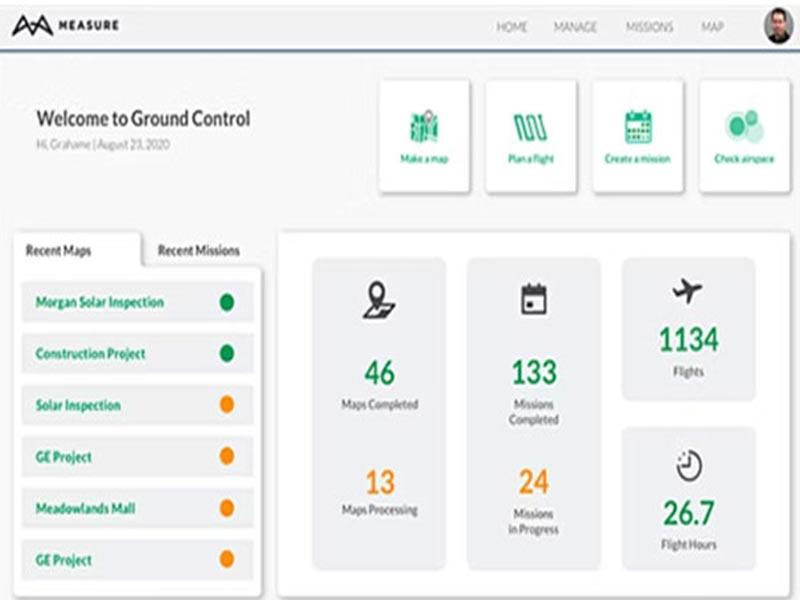
Measure Ground Control is a GIS system that assists enterprises of all sizes in streamlining activities like map generation, flight planning, mission scheduling, equipment management, inspections, and more from a single platform.
Measure Ground Construction Management lets team members ensure they follow industry rules by keeping and accessing detailed mission information, such as screenshots, playbacks, program activities, incidents, and more. In addition, the data processing feature lets employees upload ground control points (GCPs), make contour maps, design digital surface models, make orthomosaics, and measure linear distances on a single platform.
Measure Ground Control Pricing
The PRO Plan of Measure Ground software costs $69 per month (when paid in full each year) or $99 per month (billed monthly). The ENTERPRISE plan is the advanced tier. If you would like more price information, please contact the vendor directly.
Measure Ground Control Demo
Our Thoughts
Measure Ground Control gives you everything you need to automate your drone operations workflow fully. For example, staff personnel can use the flight control module to organize flights, maintain waypoint patterns, upload flight logs, obtain LAANC authorization, and monitor weather conditions. Contact our support team at (661) 384-7070 for further questions.
Measure Ground Control Features
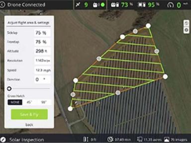
Flight Control and Data Collection
With Measure Ground Control software, you can plan and run flights from a web-based platform in the cloud. For example, you can fly a drone manually with GPS help or automatically with grid and waypoint patterns. You can also send flight plans from the web to the flight app on your phone. The Measure Ground construction management software lets you automatically upload flight logs, pictures, and data. You can also ask for permission from LAANC and stop DJI from sharing data. Last but not least, you can look at the weather and the airspace. The Measure Ground construction management software lets you automatically upload flight logs, pictures, and data. You can also ask for permission from LAANC and stop DJI from sharing data. Last but not least, you can look at the weather and the airspace.
Data Processing and Analysis
With the Measure Ground Control software, you can use Pix4D, the leader in photogrammetry, to turn images into high-quality data products. For example, with RTK drone data, you can improve image processing accuracy. The software lets you add ground control points (GCPs) to your maps. In addition, you can look at your orthos and other 2D data files on an account-wide map.
Integrations
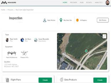
With Measure Ground Construction Management software, you can make custom reports for all types of data to meet the needs of your enterprise. In addition, you can use intelligent inspection modes to get information about specific types of assets.
Pros And Cons of Measure Ground Control
Pros
Supports and runs smoothly on older tablets
Collects survey-grade site data to provide a great business value
Offers two free maps every month
Cons
Unable to Link new drones via mobile as per user reviews
Lacks support to output DXF files
Measure Ground Control Reviews
Total 25 reviews
4.2
All reviews are from verified customers
Rating Distribution
5
Stars52%
4
Stars28%
3
Stars16%
2
Stars0%
1
Stars4%
Share your experience
James
Transportation/Trucking/Railroad, 1-10 employees
Less than a year
“Great choice”
Pros
I believe it would be an excellent product since it eliminates the need for hands, termites, and other issues.
Cons
I've really enjoyed working with it; I can't say enough good things about it.
Rating Distribution
Ease of use
10
Value for money
10
Customer Support
10
Functionality
10
Daniel
Aviation, 11-50 employees
Less than 6 months
“First Timer Review”
Pros
My first use of the MGC software was with the waypoint-autonomous mission flights. After consulting with a supervisor on operating the drone using this feature, I conducted a test flight, which went smoothly. It was easy enough that we immediately used it to capture images for a commercial job. All imaging missions were successful and produced a commercial product. This software has vast potential!
Cons
I don't have any negative feedback. As a visual learner, I would appreciate more videos demonstrating the different features in action, sort of an over-the-shoulder view of the feature being used.
Rating Distribution
Ease of use
9
Value for money
10
Customer Support
10
Functionality
10
Paul
Product, 1-10 employees
Less than 6 months
“Great value for the money”
Pros
It is very easy to use. Great overall value. Everyone should use this to stay competitive.
Cons
I needed some guidance to start, but customer support was very helpful.
Rating Distribution
Ease of use
10
Value for money
10
Customer Support
10
Functionality
10
Frequently Asked Questions
Does Measure Ground Control offer an API?
Yes, API is available for Measure Ground Control Software.
What language does Measure Ground Control support?
The platform is compatible with the English, Spanish, French, Italian, and Portuguese languages.
What other apps does Measure Ground Control integrate with?
The software easily integrates with SAP and Cheqroom.
Does Measure Ground Control support mobile devices?
Yes, the software supports mobile devices. Moreover, it also offers a mobile app for both Android and iOS devices.
What types of pricing plans does Measure Ground Control offer?
Measure Ground Control offers four pricing plans, including Basic for $29/month, Pro for $99/month, Teams for $79/user/month, and Enterprise, which offers custom pricing. Contact us for customized Measure Ground Control pricing.
Who are the typical users of Measure Ground Control?
The users of Measure Ground Control include startups, SMEs, agencies, and enterprises.
What level of support does Measure Ground Control offer?
The platform offers phone, chat, and knowledge base support.